Showing posts with label Battlefields. Show all posts

Sunday, December 17, 2006

Virtual Aerial Battlefield Tours

With the coming of winter and the corresponding disincentives to travel, I thought I'd mention an option for those who either chose to stay at home but would still like to visit a battlefield or who find themselves confined to the great indoors. Microsoft's Virtual Earth, a feature of their Live Search, allows for a unique opportunity to tour several of the Nation's Civil War Battlefields without leaving your chair or having the dogs feel neglected. This virtual search allow you to view the battlefields from a perspective ranging from 15 to 60 yards above the ground. The interactive images offer a unique opportunity to study terrain, the layout of the battlefields, or anything else that you might find.

The Angle at Gettysburg

I have included a few of the images that I found while canvasing on-line. These are each directly from Virtual Earth. For those with a dial-up connection, please forgive the slow loading time. I uploaded larger images so that people could see the images as they appear on-line. Simply click on any of the ones I've included to see the larger, more interesting version.

For those not familiar with Virtual Earth, I'll give you a quick thumbnail sketch of how to find what you'd like to see. After clicking on the link above (which should open in a separate window or tab so that you can still refer to this article), you should see a map of the United States. Having cookies enabled helps with loading time, especially in Firefox. Once it loads, you can then double click on the sections of the map that you'd like to see (it'll zoom in with each double click). For an easier way to locate sites, enter the location of your choice in the second text box at the top of the screen. It should say, "Enter City, Address, or Landmark". Fortunately, the search engine treats spelling errors kindly as it will, with limited success, attempt to guess your intentions if you're a little off.


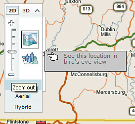
When you zoom in on a site that will allow for the "Bird' Eye View" feature, click on the box as seen in the above image. The bird's eye view allows you to zoom in closely on the battlefield and, in some instances, see some pretty decent detail.

Arlington House at Arlington National Cemetery

Unfortunately, Virtual Earth does not yet have the Bird's Eye View for all of the Civil War Battlefields. Currently, they include images of Gettysburg, Balls Bluff, Chickamauga, Richmond, Arlington, Washington DC, and Stone Mountain. When viewing Richmond, you can find some nice views of the Tredegar Iron Works (below), and the Hollywood Cemetery. For the latter, if you know the cemetery grounds, you can find the grave sites of Jefferson Davis and George Pickett, among others, and several views of the Confederate pyramid. Virtual Earth only offered limited views of Manassas and just portions of Shiloh. As of my last search, I could not find Bird's Eye View images of Vicksburg, Fredericksburg, Chancellorsville, Chattanooga, Malvern Hill, Cold Harbor, Gaines Mill, Antietam, or Harpers Ferry. They did however have the usual satellite imagery for each of these, but the quality suffers when compared to the other close-ups.

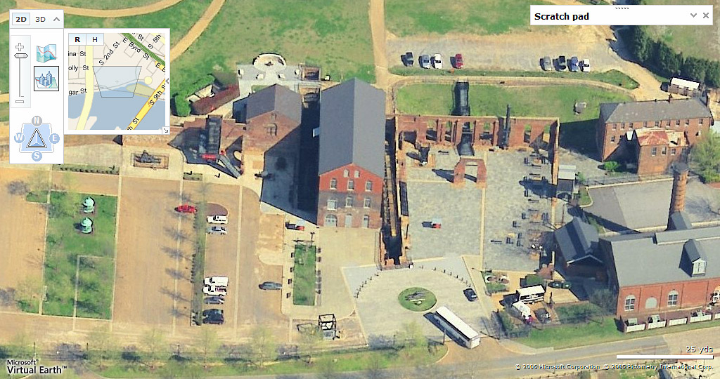
Tredegar Iron Works, Richmond, VA

When zoomed in close, you can more easily navigate the various locations by either dragging the larger image as you would in an Adobe PDF document, or by using the small navigation pane on the left (pictured in the image above). When the dragged image does not refresh, as it tends to avoid doing just when you're getting close to what you want, using the small navigation pane sometimes resolves the issue.

One other interesting feature is the compass (also pictured above) which allows you to view a scene from at least four different directions. When looking at a Bird's Eye image, just click on one of the compass points and it will offer another view. For several sites, such as Stone Mountain, the compass comes in handy since at first Virtual Earth shows it upside down.

Expect to practice a little patience as Virtual Earth at times has difficulty rendering the images or apparently simply deciding if it'll let you see them at all. Using the compass may allow you to see an image that it initially said was not available. Some of the images are perhaps a year or more old since, for example, they still show the car dealership that the National Park Service has since removed from the Battlefield at Gettysburg.

If you decide to have a look, good luck and happy hunting.

Sincerely,

Randy

Please visit my primary site at www.brotherswar.com

All original material Copyright © 2006. All Rights Reserved

Sunday, November 12, 2006

By Any Other Name

In the mid 1880s, The Century magazine published a series of articles written about the various battles of the war by the men who led their armies into those conflicts. Confederate Lieutenant General Daniel Harvey Hill wrote a section concerning the Battle of South Mountain, just prior to the Battle of Antietam. Before discussing the fighting, he took a moment to relay his thoughts on why others might instead refer to these two battles as those of Boonsboro and Sharpsburg. He also did not miss the opportunity to take a shot at those who fanned the flames of war but kept their distance from the fire.

"THE conflict of the 14th of September, 1862, is called at the North the battle of South Mountain, and at the South the battle of Boonsboro. So many battle-fields of the Civil War bear double names that we cannot believe the duplication has been accidental. It is the unusual which impresses. The troops of the North came mainly from cities, towns, and villages, and were, therefore, impressed by some natural object near the scene of the conflict and named the battle from it. The soldiers from the South were chiefly from the country and were, therefore, impressed by some artificial object near the field of action. In one section the naming has been after the handiwork of God; in the other section it has been after the handiwork of man. Thus, the first passage of arms is called the battle of Bull Run at the North,---the name of a little stream. At the South it takes the name of Manassas, from a railroad station. The second battle on the same ground is called the Second Bull Run by the North, and the Second Manassas by the South. Stone's defeat is the battle of Ball's Bluff with the Federals, and the battle of Leesburg with the Confederates. The battle called by General Grant, Pittsburg Landing, a natural object, was named Shiloh, after a church, by his antagonist. Rosecrans called his first great fight with Bragg, the battle of Stone River, while Bragg named it after Murfreesboro', a village. So McClellan's battle of the Chickahominy, a little river, was with Lee the battle of Cold Harbor, a tavern. The Federals speak of the battle of Pea Ridge, of the Ozark range of mountains, and the Confederates call it after Elk Horn, a country inn. The Union soldiers called the bloody battle three days after South Mountain from the little stream, Antietam, and the Southern troops named it after the village of Sharpsburg. Many instances might be given of this double naming by the opposing forces. According to the same law of the unusual, the war-songs of a people have generally been written. The bards who followed the banners of the feudal lords, sang of their exploits, and stimulated them and their retainers to deeds of high emprise, wore no armor and carried no swords. So, too, the impassioned orators, who roused our ancestors in 1776 with the thrilling cry, "Liberty or Death," never once put themselves in the way of a death by lead or steel, by musket-ball or bayonet stab. The noisy speakers of 1861, who fired the Northern heart and who fired the Southern heart, never did any other kind of firing."

Sincerely,

Randy

Please visit my primary site at www.brotherswar.com

All original material Copyright © 2006. All Rights Reserved

Source: eHistory.com: Ohio State University

Sunday, November 13, 2005

Changes for History

In my travels to the Eastern Theater Battlefields this past year, I was very pleasantly surprised at the many changes I encountered.

Consistent among the battlefields are the new interpretive markers whose existence we owe to the mandate to include slavery in National Park Service educational materials. Five years ago, National Park Service Battlefield Managers recommended that the Secretary of the Interior “…encourage Civil War battle sites to recognize and include in all of their public displays and multimedia educational presentations the unique role that the institution of slavery played in causing the Civil War and its role, if any, at the individual battle sites.”

Along with the markers, several of the Eastern Theater Battlefields have made significant acquisitions and changes. Despite the asphyxiating development that continues to threaten the Chancellorsville Battlefield with strangulation, the National Park Service has added to the parks lands. Along McLaws Drive is a section of land where Confederate Lafayette McLaws’ men positioned themselves to help drive General Hooker’s troops from the field on May 3rd. Although part of the Wilderness in 1863, the ground now is clear of the younger trees that choked the ground and made maneuvering so difficult.

Chancellorsville McLaws TrailThe Park Service established a walking trail and offers free of charge interpretive materials to carry with you as you walk. Included in that material, a southern soldier describes an encounter with a Confederate icon.

"Artilleryman J. B. Minor remembered that on May 2, as Lee stood under a tree with McLaws, “a 10-pound shell cut the tree square off just about a yard above their heads. I could not see that [Lee] noticed it, although General McLaws ducked a little.” A few minutes later, Minor recalled, “a shell burst immediately in front of old Traveler, who reared up and stood as straight as ever I saw a man. Captain [Edward S.] McCarthy then ran to General Lee, and I heard him say: ‘General, we can’t spare you, go back under the hill.’ He rode away, and in a few minutes there was a lull just in front of us; but there was heavy fighting some three hundred yards to our right…and whom did we see sitting on his horse calmly watching the fight but General Lee!”

A newly acquired tract of land west of the Wilderness Church allows the visitor to walk the ground of Jackson’s flank attack. Previously, the only avenue to do likewise involved carefully and courteously walking through the headstones of a private cemetery to view Jackson’s starting point. This parcel of ground renders that tactic thankfully unnecessary.

Nearby on the grounds of the Wilderness Battlefield, NPS staff continue to oversee the complete renovation of the Lacy House. A short walk from the home which served as headquarters to Major General Gouverneur K. Warren during the fighting in early May 1864, the Reverend Beverly Tucker Lacy buried the amputated arm of Lieutenant General Thomas Jackson in the family cemetery.

Antietam Final Attack TrailTo the Northwest, Antietam National Battlefield has added a walking trail over the grounds where General Burnside’s troops advanced and then were repulsed by A.P. Hill’s Light Division after his 17 mile forced march from Harper’s Ferry. Even with no knowledge of what occurred on these fields, the near two mile trail meanders through beautiful terrain and allows views of the magnificent hills and valleys. Once experienced, the typically undulating, steep, rocky, uneven ground speaks volumes concerning the difficulties commanders would encounter organizing and directing their men. With few modern intrusions, the trail leads you back 140 years to the counterattack that saved the Confederate Army for future battles.

Of course, the Gettysburg Battlefield continues its journey towards its former 1863 appearance. Most significant has been the clearing of the ground just north of Little Round Top along the Cemetery Ridge line. Minus the concealing cover of trees and brush, a commanding knoll once again thrusts itself from the shadow of the more famous rises to its south. This protruding ground reinvigorates to the question concerning Sickles’ deployment of his troops further to the west. Ringed with artillery and his veteran troops, the Butternuts would have struggled mightily to dislodge their Northern protagonists from this high ground.

A few miles north, Oak Ridge will soon appear more like its name as young oak trees planted below the observation tower take root and reach for the sun. The 13th Massachusetts monument now shares its place of honor with trees that will help recreate the vista their men encountered July 1st 1863.

The Peach Orchard also is experiencing a rebirth. The darkness before the dawn began in October when the NPS removed all 89 existing trees planted 26 years ago and suffering from a parasitic infection. After two years, new trees will call the Sherfy Peach Orchard their home.

You can find more information on the above at:

http://www.nps.gov/gett/news.htm
http://www.nps.gov/frsp/whtsnew.htm

Sincerely,

Randy

Please visit my primary site at www.brotherswar.com.

All original material Copyright © 2005. All Rights Reserved

******************
References for this article:
  1. Interpretation at Civil War Sites, A Report to Congress, March 2000
  2. National Park Service: Gettysburg

Sunday, May 15, 2005

Visiting the Gettysburg Battlefield

Several people have e-mailed about visiting the Battlefield at Gettysburg. Here is part of an e-mail that I sent in response. I removed any personal information and made a correction or two.

"What I found particularly helpful while touring the fields at Gettysburg were the self guided battlefield tours. The best of the bunch, in my opinion, is the tour produced by TravelBrains. You can find it and several others in the Visitor's Center Book Store. Most of the other tours are pretty good. One or two aren't worth buying (again just in my opinion). The TravelBrains tour lasts about 2 1/2 hours, if I recall correctly, and covers the entire battle along with some human interest stories along the way.

Another option, if your budget allows, would be to hire a Licensed Battlefield Guide. I believe that they charge $40 for 2 hours. They accompany you in your car as you drive through the park and will discuss whatever you like. They can provide a general overview or focus exclusively on aspects of the battle of your choosing. I have to admit that, at least for me, it was a bit awkward initially having a complete stranger suddenly driving around in my car. But, in the end, I found myself very much enjoying the experience. I have hired guides twice and both proved to be knowledgeable professionals. The Battlefield Guides have a reception desk inside the Visitor's Center. If you are interested, all you need to do would be to ask them if they have a guide available.

A few other options, if they have them scheduled, are the tours, walks, and talks that the park rangers conduct. They always have an events schedule inside the front doors of the Visitor's Center by the entrance to the bookstore that notes the tours on any given day. Many times there are several from which to choose."

What I didn't mention in the e-mail is one of the best ways to see the fields, at least in my opinion. If you're new to the park, after you've familiarized yourself with the battlefield, get a good map from the Visitor's Center, park your car in an area of interest, and walk the grounds. I've visited Gettysburg over 30 times and still have not found all of the markers, monuments, and curiosities within the boundaries of the park. There are rocks with carvings made by the soldiers during return visits to Gettysburg. Some placed plaques in obscure locations where an event significant to the soldiers occurred. The monuments themselves have a wealth of information if you take the time to read their inscriptions. The bookstore has a map which specifically notes every monument, marker, and placard on the field. It's a great reference and it's waterproof.

Of course, the experience changes depending on the time of the year. Many people love visiting in July during the Battle's anniversary. But I can say from experience that, except for early morning, spots like the Copse of Trees, Devil's Den, and Little Round Top, among others, are usually quite crowded during the mid-summer months.

Also, please beware of ticks and poison ivy if you choose to go off the beaten path.

I should say that relic hunting is strictly forbidden and, if you decide to ignore this taboo, you could find yourself in an awkward situation. Remember that these are Federal grounds. But more important than the potential penalties is to remember what occurred at Gettysburg and to do your part to preserve those sacred grounds for future generations. I would respectfully request that visitors keep children from climbing on monuments and cannons and especially the larger rocks on Little Round Top and Culp's Hill. Many have carvings that are disappearing due to wear and erosion, many of which are no longer obvious.

Anyway, for those thinking of Visiting Gettysburg, I hope that helps. For more information, please see the Gettysburg.com site listed under "Links".

Respectfully,

Randy

All original material Copyright © 2005. All Rights Reserved.